Tropical Depressions, Tropical Storms & Hurricanes: What’s the Difference?

A tropical depression, a tropical storm, and a hurricane are all different stages of tropical cyclones, which are intense weather systems that originate over warm ocean waters. While these terms are sometimes used interchangeably, there are distinct differences between them in terms of size, wind speeds, rainfall amounts, and overall impact on nature, people, and infrastructure. Let’s explore how they form, are categorized, and the overall effect of each weather system.
How Does a Tropical Cyclone Form?
The process begins with warm ocean waters, typically with temperatures above 79°F. The warmth of the ocean is what provides the energy for a cyclone to develop, which is why the vast majority of them originate in the tropics and near the equator, where the ocean temperature is warmest. As the water evaporates, it creates warm, humid air that begins to rise and eventually condenses to form clouds. The condensation then releases latent heat, which further warms the air, causing it to rise even more rapidly.
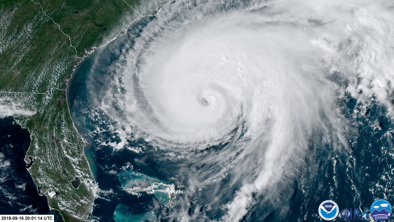
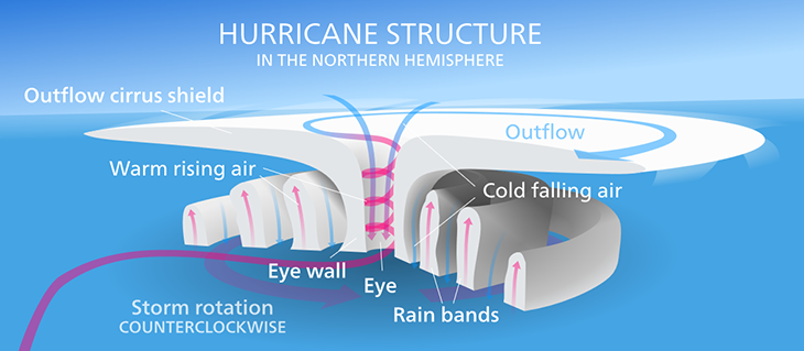
As the warm air continues to rise, it creates a low-pressure area at the surface. Surrounding air rushes in to fill this low-pressure void, strengthening the windspeeds. For the system to develop into a cyclone, the Coriolis effect, due to the rotation of the earth, causes it to start spinning, which helps to organize the storm. As it strengthens, it develops a well-defined center of rotation, otherwise known as the eye of the storm. A ring of intense thunderstorms, called the eyewall, surround the eye and branch outwards, creating the characteristic spiral shape of a tropical cyclone.

Tropical Depression
A tropical depression is the least intense stage of a tropical cyclone. When a low-pressure area gathers thunderstorms with an organized circulation pattern that persists for at least 24 hours, it is categorized as a tropical depression. The primary characteristic of a tropical depression is sustained maximum winds of up to 38 miles per hour. These systems are typically smaller in size than tropical storms or hurricanes, with a diameter ranging from 100 to 300 miles. Despite their relatively low wind speeds, tropical depressions can still result in heavy rains and localized flooding, leading to infrastructure damage. For the most part, however, they are not very dangerous storms.
Tropical Storms
If a tropical depression gains enough strength, it can progress into a tropical storm. The defining factor for this transition is the establishment of the circular thunderstorm pattern accompanied by maximum sustained winds between 39 and 73 mph. At this stage, the tropical storm starts to develop a more defined structure, with more organized bands of thunderstorms rotating around the center. These bands can extend outward for several hundred miles, potentially affecting a much larger area than a tropical depression. Once a tropical depression becomes a tropical storm, the system often gets named for the purposes of tracking it meteorologically and historically. Tropical storms can last several days or even weeks and can cause significant amounts of damage to homes and infrastructure via strong winds as well as flooding from heavy rains or storm surges.
Hurricanes
Finally, a hurricane represents the most powerful and dangerous stage of a tropical cyclone. Hurricanes are characterized by maximum sustained winds of 74 mph or greater. They also possess a well-defined eye, which is a relatively calm area at the center of the storm, and the eyewall surrounding it is often where the strongest winds and heaviest rainfall occur. Hurricanes can reach enormous sizes, with diameters exceeding 600 miles. They last for several days or even weeks, and their potential impact can be devastating due to their wind speed, storm surge, heavy rainfall, and even the potential for spawning tornadoes.
Hurricanes are broken into five categories based on the intensity of the sustained wind, with a Category 1 being the weakest and Category 5 being the strongest. Hurricanes in Category 3 and higher are considered major hurricanes because of their potential for significant loss of life and damage. Though Category 1 and 2 storms are still dangerous and require preventative measures, Categories 3 and higher are almost certain to cause catastrophic damage to buildings, homes and infrastructure like power grids, water systems and roadways.
Strengthening of Tropical Cyclones
The main contributing factor to the strengthening of a tropical cyclone is the warmth of the ocean. Warmer waters mean more intense storms, which is why most Atlantic hurricanes do the most damage in the Caribbean, Gulf Coast and Southeast United States, and are often downgraded to tropical storms or depressions by the time they reach the Northeast United States and Canadian Maritimes. It also means that as ocean temperatures rise throughout the years, we will continue to see more and more tropical cyclones developing into tropical storms and hurricanes.
Impacts of Tropical Cyclones
The impacts of a tropical cyclone can vary depending on its intensity, size, forward speed, and the geographical location it affects. Tropical depressions can bring heavy rainfall and localized flooding, posing risks to life and property. Tropical storms can cause more significant flooding, increase the potential for landslides, and also generate strong wind gusts capable of damaging structures and vegetation. Hurricanes, being the strongest stage, have the potential to unleash catastrophic damage. Their powerful winds can destroy buildings, uproot trees, and cause widespread power outages. The storm surge, a rise in sea level caused by the hurricane’s winds and low atmospheric pressure, can flood coastal areas and cause coastal erosion. Additionally, the tremendous rainfall associated with hurricanes can result in life-threatening flash floods and mudslides.
How Do Tropical Storms & Hurricanes Move?
Tropical storms and hurricanes move due to a combination of several atmospheric and oceanic factors:
- Steering Winds: The primary factor is the surrounding atmospheric winds, particularly the trade winds and the prevailing westerlies. In the tropics, trade winds, which blow from east to west, generally push the storms westward, and as they move further north, they often encounter westerly winds that steer them eastward and back out to sea, where they eventually dissipate in the cooler waters of the northern Atlantic.
- Coriolis Effect: The rotation of the Earth also influences the path of tropical storms and hurricanes. The Coriolis effect causes hurricanes in the Northern Hemisphere to curve to the “right,” or eastward, and is also the cause of the general counterclockwise rotation (in the Northern Hemisphere) of the storm itself.
- Pressure Systems: High and low-pressure systems also play a role in the movement of tropical storms and hurricanes, as they tend to move towards areas of lower pressure. High-pressure systems can act as a barrier, blocking a hurricane’s path and causing it to alter course.
- Ocean Currents: While not as influential as atmospheric winds, ocean currents can also affect a storm’s path, especially when combined with a prevailing wind or low-pressure system moving the storm in the same direction the current is travelling.
The combination of these factors determines the specific track and speed of a tropical storm or hurricane, which is why the exact path of a storm is difficult to predict and why forecasters and meteorological models often give conflicting reports about where a given storm is headed.

How Weather Instruments Help You Stay Prepared & Informed
The most valuable instruments in helping you stay informed and prepared for hurricanes are barometers and anemometers that include wind direction readings, as atmospheric pressure and wind speeds are the main driving factors of a storm’s strength and path. For example, if you live in an area where it is unclear whether or not you are in the path of a storm, those two instruments can help give you a better idea of he track of the storm. If you have a barometer at home and see the atmospheric pressure drop in your area, it is more likely the storm will head your way, whereas the opposite is true if the pressure rises. Measuring wind speed and direction can help in the same way, as strong prevailing winds can push the storm towards, or away from, your location.
Tide clocks can also help you better prepare for a storm in a coastal area, as damage from storm surges will be far greater if a storm makes landfall at high tide vs. low tide. For example, a storm with a five-foot surge that hits an area where tides have a four-foot range would cause the sea level to rise by seven-feet above the mean if it makes landfall at high tide, and only three feet above the mean if it makes landfall at low tide, which would result in drastic differences in the amount of flooding in the area.
In addition, an instrument like a rain gauge, while not useful for predicting a storm’s path or intensity, is helpful in determining how much rain fell in your specific location during a storm. Rainfall amounts can vary widely in different across the diameter of the tropical cyclone and reports in the aftermath of a storm often only include averages.
To learn more about these different types of weather instruments and stations, visit our linked product pages or feel free to contact us. To learn more about different types of storms, click here to read our article on winter storms.


